Let's Discover and Rediscover

Let's discover and rediscover the Paradise Philippines!

Located in the heart of Southeast Asia is the Republic of the Philippines (often called on this blog the Paradise Philippines), the second largest archipelago in the world with 7,107 islands and a mixture of Malay, Chinese, Spanish and American influences.

Majority of the 72 million Filipinos are Christian, with significant numbers of Muslims and indigenous people. The Paradise Philippines is a tropical country with dry and wet seasons. It's also the world's third largest English-speaking nation.

The country is divided into three geographical island groupings-- Luzon, Visayas, and Mindanao. Metro Manila is the seat of government and the premier international gateway. Embracing the capital of Manila and several cities and municipalities, it's the heart of the country's social, economic, and cultural life.

Luzon is the largest island, with 55% of the country's population residing there. It's home to the Cordillera, Sierra Madre, and Caraballo mountain ranges, volcanoes such as Mayon, Taal and Pinatubo, and the Paradise Philippines largest lake, Laguna de Bay.

The Visayan islands are characterized by natural and cultural diversity. The beaches of Boracay are regarded as some of the world's best. Cebu is the cradle of Christianity in the Paradise Philippines. Bohol has one of the world's most intriguing geological formations.

Mindanao, the second largest island, is the seat of Muslim culture and homeland of colorful ethnic tribes. Davao is geographically the largest city in the world, while Mount Apo is the Paradise Philippines highest peak. Zamboanga along with the Sulu archipelago is fabled for its seafaring communities.

Ready to travel to Paradise Philippines?

Mountain Systems

Paradise Philippines Mountains
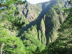
The Mountain Systems of "Paradise Philippines".

Here are the mountains that you can find in Paradise Philippines. There are three large range in the mountain system of Luzon which form rampants around the Central Plains. The Caraballo del Sur, which forms the nucleus of the system, has its highest peak at the intersection of the boundaries of Abra, Ilocos Norte, and Cagayan. The Caraballos Occidentales divide into the Cordillera Norte and Cordillera Central and traverse the region west of the Cagayan river. Mt. Pulag, the second highest peak of the Philippines is located there. The Sierra Madre, also known as the Pacific coast range, begins at Baler, Quezon, and crosses Isabela, Nueva Viscayam and Cagayan. This is the longest continuous range in the Paradise Philippines. The mountain range of the eastern and southeastern provinces of Luzon extend from the Caraballo de Baler to San Bernardino Strait in the south, culminating in Mayon Volcano in Albay and Bulusan Volcano in Sorsogon.

The Zambales range starts at Cape Bolinao and follows the China Sea coast to the Bataan Peninsula. The Tagaytay range paases through Cavite and Batangas and, with Mt. Makiling, forms the mountain system of the southern Tagalog region.

The Mindoro mountain range begins at Mt. Halcon and is divided into three ranges: the northwest ending at Calavite Point, a landmark of ships passing between Manila Bay and Mindoro Strait; the east, ehich originates from Lake Naujan; anf the West, which follows the Mindoro Strait.

Negros in the Visayas is divided into two by a range running from norhtwest to southeast, with Kanlaon Volcano as the notable Peak. Panay has a range running from north to south that separates Antique from Iloilo, Capiz, and Aklan.

Mindanao has four district ranges: the Surigao range which follows the countours of the Pacific coast ; the Butuan range which extends to the south and forms the watershed of the Agusan River on the east and the Palangui River on the west; the central-western ranges of which Mt. Apo is the highest; and the Western range which begins west of Iligan Bay and the ends on the shore of Basilan Strait.